Introduction
The site has humps and hollows in a grass field, the remains of a formal garden which surrounded the 1690s house. An engraving of Dumbleton Hall by Johannes Kip in 1712 shows a formal landscape. A new information panel shows very clearly where the original canals and walkways shown in the Kip engraving were.
Undulations in the grounds give some impression of the garden layout shown in the Kip engraving that was published in 1712. There are a couple of large trees growing on the site.
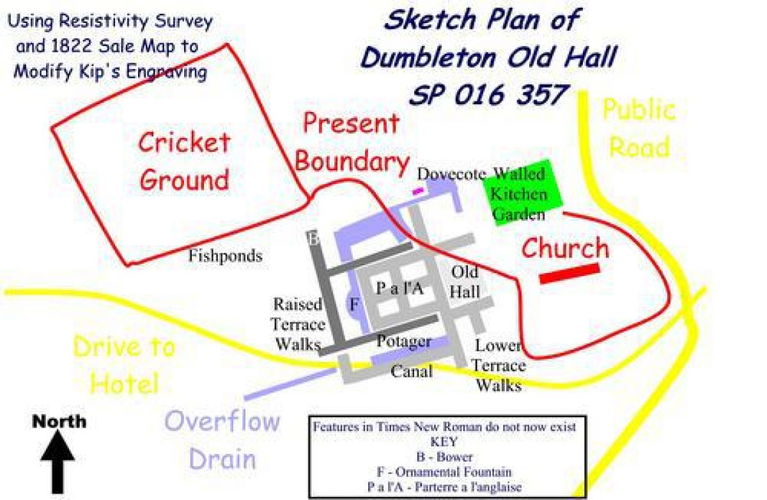
The sketch plan given by J. C. L. Ellis-Marshall in the first edition of a pamphlet 'Lands called Dumbleton' is probably a misinterpretation of the Kip engraving, which was partially confirmed by a resistivity survey.
However, the 1822 sale map shows a north-south arm of the canal between the D-shaped pool and the house up to the northern canal. Though this feature is omitted from both the Kip engraving, and the Ellis-Marshall sketch, it probably existed in 1712. Thus Kip's engraving cannot be relied upon, and probably exaggerated the extent of the garden.
In 1712 Dumbleton Old Hall is across a carriage drive from the church. Its south front faces a park between twin tree avenues, of which no vestige remains.
The western elevation of the Old Hall fronts a parterre a l'Anglaise. Raised terraced walks about one metre above the parterres surrounded it. The furthest cross-raised terrace was an allee with a bower at its northern end.
The channel that fed the water supply is visible. The 1822 sale map indicates a pool about SP01253541, which may have been involved.
There is a central path that led to a D-shaped pool with a statue making an ornamental fountain. It was likely to have been gravity-fed using springs on Dumbleton Hill. It then flows under the raised terrace walk on the north side to a canal that linked to another canal along the northern side of the garden. At its eastern end it widens to provide a farmyard pool close to the stables. These are marked as fishpools on the schedule associated with the 1822 sale plan.
On the western side of the pool was a dovecote.
The canal on the southern side of the garden appears to been at a lower level. It lies alongside the potager below the southern raised walkway.
Beyond the western end of the garden Kip shows a plantation, while tree avenues line approaches from the south.
Maps
Ordnance Survey 25 inches per mile Gloucestershire XIII/6 1884, 1923
Ordnance Survey 6 inches per mile Gloucestershire XIII NW 1891
Ordnance Survey 1:10,000 1981
Sale Particulars 1822 GA SL163 & 198
Sale Particulars 1875 GA SL164,481
Road Changes 1830 GA Q/Srh/1830/D/2
- Visitor Access, Directions & Contacts
Directions
Visible from the drive to Dumbleton Hall.
Owners
Charles Hambro
- History
Dutch-style Water Garden
The Dutch-style water garden shown on the Kip engraving was probably built when Sir Richard Cocks rebuilt the manor house after acquiring it in 1684.
Chronology
1534 Sir Thomas Pope granted the Manor of Dumbleton upon the dissolution of the monasteries.
1554 The estate was inherited by Edmund Hutchins, son of Sir Thomas Pope's second sister. He married Dorothy Cocks in 1556, to whom the estate was transferred when he died in 1602.
1628 Sir Charles Percy, the second husband of Dorothy Cocks, died.
1646 Charles Cocks, Dorothy Cocks' brother, a bachelor, inherited the estate.
1654 Sir Thomas Cocks from Castleditch, Herefordshire inherited, becoming High Sheriff of Gloucestershire in 1655.
1684 Sir Richard Cocks (about 1659-1726) inherited the estate and rebuilt the house with seven bays, possibly designed by Roger or William Hurlbutt, shortly afterwards. He had no children, although he was married twice.
1710 The likely date of Kip's engraving, published 1712.
1726 Sir Richard's brother, the Reverend Sir Robert Cocks DD inherited the estate.
1740 He was succeeded by his fourth son, Sir Robert Cocks.
1765 Sir Robert died after falling from his horse. His daughter Dorothy continued to live at Dumbleton.
1767 Dorothy died, aged 18, and the manor was closed. The title passed to Charles Cocks of Castleditch, Herefordshire. The house was partly pulled down and partly used as a farmhouse.
1822 Sale particulars for this time show that some water features and a building on part of the site of the former hall still existed. The area is described as ‘Great House, Bowling Green, Fish Pools, etc' and ‘Garden'.
1830s A new house, Dumbleton Hall, was built further from the village to the west.
1875 The estate's plan in the sale particulars of this date gives no indication of any survival of any feature.
- Features & Designations
Style
Formal
Features
- Dovecote
- Fishpond
- Canal
- Ornamental Fountain
- Bower
- Terrace
- Parterre
- L'anglaise
- Potager
- Tree Avenue
- Plantation
- Terraced Walk
- Allee
- Key Information
Type
Estate
Purpose
Ornamental
Survival
Part: ground/below ground level remains
Hectares
1
Civil Parish
Dumbleton
- References
References
- pages 405-407 The Ancient and Present State of Gloucestershire
- pages 420-422 A New History of Gloucestershire
- pages 126-127 The Country Houses of Gloucestershire, Vol. II 1660-1830
- No 36, pages 23-27 Glevensis
- Especially page 12 Lands called Dumbleton (1st Edition)
- Dumbleton Parish Survey of 1822
Contributors
Joan Shillito assisted by Gay Chamberlayne