Introduction
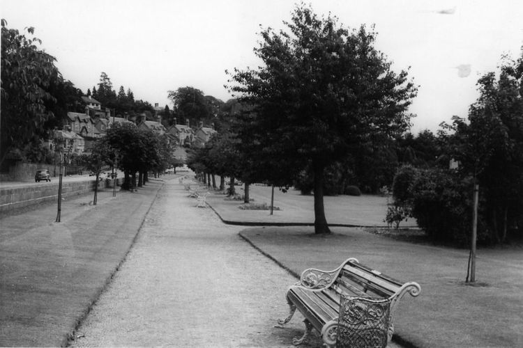
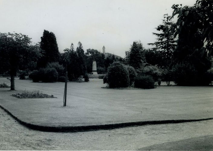
Memorial Park remains largely consistent to the original 1920s park layout, comprising of lozenge shaped planting beds surrounding the centrally located War Memorial. The park's aesthetic value is both in the parks tree collection and setting, which includes long views towards the Wallace Monument. The Henderson Street boundary is planted up with ornamental Cherry trees which are much valued by the local community which includes students from nearby Stirling University campus.
Terrain
Ochil Hills descend to meet Allan Water valley and carse landscape to southSize, Location and Setting
Memorial Park is 1.2 hectares in size and is located inside the Conservation Area within the town of Bridge of Allan, Stirlingshire.
Bridge of Allan is situated some 3 miles north of Stirling and has a population around 5,100 (2008 figures).
Bridge of Allan is described in Stirling Council's Conservation Area Statement as a small suburban town on the Allan Water located to the west of the Ochil Hills. The town developed on the site of earlier mining settlements and later as a Spa resort in the Victorian era. The town grew around the main street, Henderson Street, formerly MacFarlane Street, the historic road which linked Bridge of Allan with Stirling and Dunblane. The broad thoroughfare of Henderson Street divides Bridge of Allan into the Lower and Upper Towns. The Upper Town was laid out at the edge of Mine Woods, and is an excellent example of Victorian development of large detached villas, set within extensive grounds along elegant promenades. The Lower Town represents an equally pleasing later mid-20th century detached housing development.
The Bridge of Allan Conservation Area comprises a significant area of the townscape, which includes Memorial Park on its south-east boundary.
Layout
A plan of the original park layout, as conceived by Mr. Lunt, head gardener at nearby Keir Gardens was not uncovered during the study. However, analysis of historic Ordnance Survey maps, together with historical photographs, and the current features within the park, confirm that much of the current layout is consistent with the original park layout dating from the 1920s. This includes the tree avenue to Henderson Street, which features ornamental Cherry trees, together with the two groups of Red Horse Chestnut trees; the symmetrical layout of the lozenge shaped planting beds; the circular planting beds to either side of the central axial path leading to the War Memorial, together with the semi-circular Yew hedges either side of the centre circle; the regular planting of Red Oak, Cappadocian Maple and Holm Oak around the perimeter crescent, inter-planted with exotic firs, and under planted with evergreen shrubs including Rhododendron.
Nothing is known about the shrubs which Lunt selected for the lozenge shaped beds and perimeter planting beds.
Analysis of Lunt's (assumed) original planting layout reveals the following. His intention was to provide seasonal interest along Henderson Street through the introduction of spring flowering ornamental Cherry trees, and summer flowering Red Horse Chestnut trees.
The lozenge shaped beds which are symmetrical to the central axial path, were designed to screen and then reveal the centrally located War Memorial as one walked or promenaded along the perimeter paths.
Upon entering the Park at the main entrance on Henderson Street, the path is aligned on the central feature, the Memorial. The shrub and tree planting to the ‘D' shaped crescent was designed to form a backdrop to the Memorial. When looking towards the Memorial from the main entrance, the Holm oaks are viewed to either side of the Memorial, which are flanked by Red Oaks, followed by the Cappadocian Maples. This pattern was as far as we can determine, repeated around the crescent and under planted with Holm Oak and evergreen shrubs, probably of high horticultural interest such as Rhododendron.
The area around the Memorial was deliberately void of tree planting, presumably so not to detract from the setting of the Memorial.
Entrances and Approaches
There are four entrances into Memorial Park. The main entrance is on Henderson Street on the north boundary of the park, and is aligned with the Memorial. The secondary entrance is on Keir Street, the south boundary, and is also aligned on the Memorial which is centralised equidistantly between the two entrances. There are two side entrances into the park off Henderson Street, located on Keir Street and Graham Street, the east and west entrances. These entrances terminate the tree-lined boulevard which runs parallel to Henderson Street.
Natural Heritage
Of the existing trees within Memorial Park. There are 35 different species, of which 17 species are deciduous and 18 evergreen. Considering the small footprint of the park, only some 1.2 hectares, this represents a remarkable variety of tree species within a relatively small area.
Of the deciduous trees, there are many notable species including:
Cappadocian Maple Acer cappadocium, valued for its butter yellow leaf colouration in autumn;
Red Horse Chestnut Aesculus x carnea were planted in groups of four as a central feature within the tree avenue to Henderson Street. Due to their size, they have been managed by pollarding;
The three varieties of ornamental flowering trees within the tree avenue: The Purpled-leaved Cherry Prunus cerasifera ‘Pissardii'. The ornamental flowering Cherry, Prunus ‘Kanzan', one of the most familiar park trees, known for its profusions of large double pink flowers. And Prunus lannesiana, a genus of which there are many cultivars;
The Red Oak Quercus rubra, which are planted around the ‘D' shaped path to complement the butter yellow foliage of the Cappadocian Maple;
Of the evergreen trees, there are many notable species including:
Holm Oak Quercus ilex, whose native range spreads from Spain along the Mediterranean fringe and eastwards to Pakistan, and is therefore a long way from home in Bridge of Allan;
Western Hemlock Tsuga heterophylla, a species discovered by Scottish plant hunter David Douglas in 1828 in its native range of North America. However, it was not brought to Europe until 1852. At one point the species name was changed to albertiana at the request of Queen Victoria because she had such a high regard for it;
Two Hiba Thujopsis dolabrata, unusual as it is the only species in a monotypic genus, often called the False Arbor-vitae. It is the tree's foliage, supposedly hatchet-shaped, which gives the tree its name. From the Latin "dolabra" (a hatchet);
Western Red Cedar Thuja plicata;
There are five species of False Cypress within Memorial Park. Lawson Cypress Chamaecyparis lawsoniana is a tree with strong Scottish connections, having been introduced by Scottish botanist Andrew Murray in 1854 from the upper Sacramento Valley in California. Seed was sent to the Lawson Nursery in Edinburgh and was soon distributed to customers as an evergreen ornamental. Its low nutrient requirements and shade tolerance make it an indispensable urban tree, and false cypress make fine individual specimen trees;
Nootka Cypress Chamaecyparis nootkatensis. Again it is a tree with Scottish roots, having been ‘discovered' by Archibald Menzies in 1790. However, it did not arrive in Britain until 1853. Menzies travelled to the east coast of America and the West Indies in his plant hunting;
The single Giant Redwood Sequiodendron giganteum also referred to as Wellingtonian, and Giant Sequoia, another Menzies discovery within Memorial Park. This tree is located on the Keir Street boundary. The Memorial Park Giant Redwood has grown to 27 metres in height;
Arolla Pine Pinus cembra.
It is noteworthy that not a single native tree species formed part of the tree species selected by Mr. Lunt for the original planting scheme.
Built Heritage
War Memorial
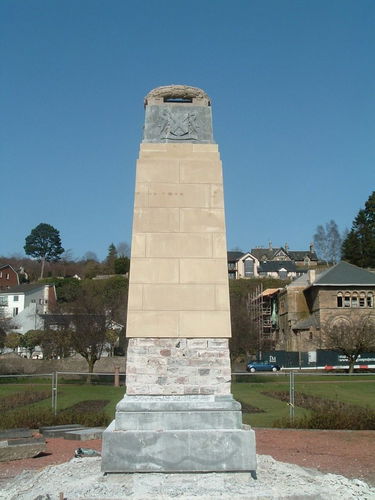
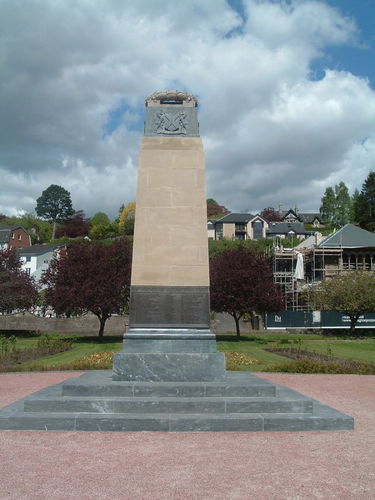
The War Memorial was refurbished in 2008-09 and is in good condition. The refurbishment cost amounted to £31,500.00, of which £21,500.00 was raised by the local community.
Refurbishment work to the memorial involved the dismantling and rebuilding of the memorial incorporating existing and new stone around a rebuilt brick core. The existing granite steps were lifted and reset on a concrete base. This involved installing a new Bardiglio Nuvolato, an Italian marble step unit. Refurbished bronze plaques were fixed to the rebuilt core. New Peakmoor sandstone facing ashlar blocks were fixed onto the existing weathered sandstone blocks, and the top section comprising the original ashlar masonry and bronze laurel wreath rebuilt.
Masonry Walls and Steps
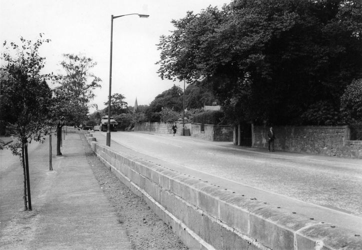
The masonry retaining wall which runs along the Henderson Street boundary is in reasonable repair. The railings were removed, presumably during the Second World War. Some cope stones, including the end scroll stone copes have become dislodged. The three flights of steps located at the main entrance on Henderson Street, and the two flights of steps leading to the War Memorial are in good order.
Paths and Surfaces
Historic photographs reveal that the paths have always been set below the surrounding ground levels, and finished in a loose aggregate surface.They are unedged.
Given that the paths are generally set below or level with the surrounding ground level, all paths are affected with waterlogging. After periods of prolonged rain fall all paths are affected. The perimeter path parallel to Keir Street which includes the secondary entrance is worst affected.
Furniture
None of the original cast iron bench seats evident in historic photographs are evident today.
- Visitor Access, Directions & Contacts
Directions
There are pedestrian entrances on Henderson Street and Keir Street.
Owners
Stirling Council
Land Services, Allan Water House, Kerse Road, FK7 7SG
- History
Bridge of Allan was established as a grand Victorian Spa development in the 19th century. The settlement had originally established around the early-1700s bridge crossing the Allan Water. Two significant estates, or designed landscapes, are situated to either end of the town. The Kier Estate to the west, and Airthrey Castle estate to the east. The Airthery Castle estate is now Stirling University campus, listed by the International Council of Monuments and Sites (ICOMOS) as one of the top 20 heritage sites of the 20th century within the UK.
In the aftermath of the Great War communities throughout the British Isles were encouraged to celebrate the Armistice, and consider how best to commemorate those servicemen who had given their lives for Queen and Country. In Bridge of Allan, the town's Provost established a War Memorial Committee to oversee the erection of a War Memorial. Mr Edmund Pullar of Westerton House, Bridge of Allan, a philanthropist and major benefactor to the Burgh, made the very generous offer to finance the erection of the War Memorial, and donate the land within which it would be located.
Mr Pullar reserved the right to approve any plans for the layout and development of the park, and took considerable interest in the construction of the War Memorial and the laying out of the park. He was able to see the project come to fruition before his death in 1926.
The Agreement between Edmund Pullar, Esq, Westerton House, Bridge of Allan and The Provost, Magistrates and Councillors of the Burgh of Bridge of Allan dated the 16th and 23rd September 1919 records the deed of gift from Edmund Pullar of the land between Henderson Street and Keir Street. A Plan prepared by Messieurs McLuckie and Walker Architects, Stirling was annexed to the Deed.
The central feature within Memorial Park is the War Memorial, which was designed by local architect, and resident of Bridge of Allan, John Stewart (1869 -1954), of architectural practice Stewart & Patterson, who were commissioned to produce ‘something suitable and appropriate. Something that Bridge of Allan could look upon with no feeling of shame.'
In addition to the memorial, a boulevard was to be formed with trees planted parallel to Henderson Street. Around the park's perimeter there was to be a path planted with shrubs. There was also a central path leading to the memorial with flower beds on either side. The cost of Memorial Park is thought to have been £2,000 in 1923.
Minute from Bridge of Allan Town Council dated 6th March 1923 records ‘The Committee met at the Memorial Park to consider the plan of the lay-out of the Park, and Mr. Stewart, Architects, and Mr. Lunt, Keir Gardens, who were present submitted and explained the plan. Having heard Mr. Stewart and Mr. Lunt the Committee approved of the plan of the layout of the park, and in view of the advanced season for planting out trees and shrubs it was agreed that Mr. Lunt should procure forthwith the trees to be planted in the boulevard, the remainder of the trees required to complete the work to be procured in time for planting next season.'
The memorial was unveiled in a ceremony given by Mr Edmund Pullar of Westerton, the Depute Lieutenant. Territorials from the Argyll and Sutherland Highlanders in full dress uniform mounted a guard with fixed bayonets. The local school band played, and 80 ex-service men were invited. Afterwards there was a reception in the Museum Hall.
An historic photograph titled War Memorial and Museum Hall, Bridge of Allan reveals an early view of the curtilage to the War Memorial, probably 1924. Analysis of this photograph reveals the wreaths which have been placed around the base of the Cenotaph following Armistice Day. The photograph reveals the individual yew plants which make up the semi-circular hedges either side of the memorial. Despite this photograph being of good quality, it is not possible to locate trees along Henderson Street, only a timber fence. The photograph confirms that the trees were added after the Memorial, during the first or second available planting season as recorded in the Town Council minute.
In 1926 money was raised to replace wooden steps with Auchenheath stone, a honey coloured sandstone quarried near Lesmahagow in Lanarkshire, and to buy more plants. Edmund Pullar gifted Douglas fir trees planted around the park's Tennis Courts.
An historic photograph titled War Memorial and Public Park, Bridge of Allan reveals a slightly later view of the curtilage to the War Memorial, around 1930. The photograph reveals one of the kidney bean shaped planting beds in the foreground, containing juvenile plants. The timber steps to the memorial are evident, as is the circular embankment surrounding the memorial which appears to contain display bedding. The two semi-circular Yew hedges and bench seats located to either side of the memorial are evident. The individual yew plants have established to form a hedge. The individual circular beds along the central axis are also evident. Despite the relative poor quality of the photograph it is possible to identify the trees which form the avenue to Henderson Street in the background, along with the railings to the masonry wall along the Henderson Street boundary.
In 1947 there was a re-dedication ceremony to unveil a new plaque to commemorate those servicemen who had fallen in World War 2.
An historic photograph across Memorial Park from an elevated vantage point from Coneyhill Road, around 1940, reveals the park some 15 years after planting. The tree avenue, complete with tree stakes can be seen in the foreground, as can the railings to the wall on Henderson Street. On close examination, the swan neck back stays are visible, as is a detail within the top rails to the railings, centrally located within each railing panel. The establishing planting beds are evident within the park, as is the hedge along Graham Street.
An historic photograph titled Memorial Park, Bridge of Allan reveals a later view of the park, around 1955, gauging the age of the cherry trees in the foreground. The photograph was taken from an elevated vantage point to the north-east of the park, probably out of a first floor window to Museum Hall. The photograph records Memorial Park some thirty years after it was laid out. Established cherry trees in blossom within tree avenue along Henderson Street boundary are in the foreground. The established kidney or lozenge shaped planting beds are in the middle ground, set within a highly manicured grass lawn. The semi-circular Yew hedges to either side of the memorial have matured. Spring bulbs (daffodils) can be seen in the foreground and to either side of the Keir Street entrance. The tree and shrub planting which forms the crescent shaped planting bed to Keir Street is indicated for the first time. Individual deciduous trees, including the oak which have yet to come into leaf can be identified, as can the form of the evergreen trees including the giant redwood. Circular beds are discernable to either side of the memorial along the axial path.
In the 1980s ‘The Peace Garden' was laid out within Memorial Park. It reflected the local community's views on Nuclear disarmament and consists of ornamental trees, each with a dedication plaque, which are set around a central granite stone which is inscribed ‘This Garden is Dedicated to Peace' and includes the carving of universal symbol of peace a dove.
Period
- 20th Century (1901 to 2000)
- Early 20th Century (1901 to 1932)
- Associated People
- Features & Designations
Designations
Conservation Area
Features
- War Memorial
- Description: The War Memorial is an Obelisk, sculpted from Hepton Wood grit stone, set on a plinth consisting of three marble steps. The names of fallen soldiers are displayed on bronze plaques which are set around the base of the obelisk. These plaques originally recorded soldiers from World War 1. Names of soldiers who fell during World War 2 were added in 1947. A plaque reads ‘RAISED IN HUMBLE GRATITUDE TO THE MEMORY OF THE MEN OF BRIDGE OF ALLAN WHO DIED IN THE GREAT WAR’. A Laurel wreath carved in sandstone surmounts the obelisk. The south face displays a shield with a cross and star. The west face displays the badge of the Argyll and Sutherland Highlanders. The north face displays a shield of two unicorns and the cross of Saint Andrew. The east face displays the badge of the Black Watch.The steps to the memorial are made of Bardiglio Nuvolato, an Italian marble which display deep white veins within the grey stone. The War Memorial is included in the UK National Inventory of War Memorials www.ukniwm.org.uk as Ref. 5791.
- Earliest Date:
- Latest Date:
- Key Information
Type
Park
Purpose
Commemorative
Principal Building
Parks, Gardens And Urban Spaces
Period
20th Century (1901 to 2000)
Survival
Extant
Hectares
1.2
Open to the public
Yes
Electoral Ward
Logie
- References
References
- Allan, J.M. {Bridge of Allan in Old Postcards: A Story in Pictures, 1895-1945} (Stirling: Stirling Council Library Services & Dr. W.H. Welsh Educational and Historical Trust, 1996) Bridge of Allan in Old Postcards: A Story in Pictures, 1895-1945
- William F. Hendrie {Old Bridge of Allan and Blairlogie} (Catrine: Stenlake, 2007) Old Bridge of Allan and Blairlogie
Contributors
Matthew Benians, TGP Landscape Architects